Kansas City Streets
from the viewpoint of a pedestrian
The good--the bad--the ugly
by Brent Hugh
| Pedestrians need to go to all the places motor vehicles go--and for all the same reasons. |
The Good
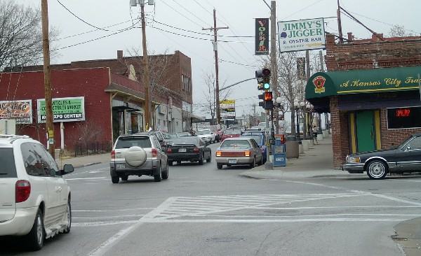
This is a vigorous pedestrian-friendly area at 39th and State Line, near KUMed Center. A friend of mine lived a few blocks from here, but then moved north of the river to a "nicer" neighborhood. She and her family soon ran back to this neighborhood with their tails between their legs. The gist of her reasons for moving back: "On State Line I could walk or bike everywhere I needed to go--to the doctor, to the store, to dozens of interesting restaurants. In the northland I couldn't even walk down my own neighborhood street--which had no sidewalks--without being honked off the road by aggressive drivers."
When our twins were born I spent a week in this area. I was amazed at the variety of shops and restaurants within easy walking distance. There are far more restaurants within easy walking distance of the intersection shown here, than in all of Raytown (~50 square miles), where I live.
What does this area have going for that makes it so vital and liveable?
- Businesses are right on the street where passers-by can browse and develop interest in visiting them. Most parking is in the back, out of the way.
- Crosswalks and pedestrian signals are at every intersection. They may not be beautiful or perfect, but they are present and working.
- Parking on sides of street makes the street appear narrow and irregular to drivers. This helps slow travel speeds and makes drivers watch.
- Reasonably wide sidewalks give room to move.
- On-street parking, lightpoles/trash cans/flower pots give a clear sense of separation between pedestrian and traffic.
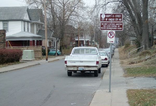
- Relatively narrow streets, plus parking along the side, helps calm neighborhood traffic on this typical residential side-street.
- All connecting neighborhood streets have sidewalks and calm traffic. Thus neighbors can (and do) walk here to shop and visit.
- They make some effort to pick up the garbage that blights so many other area streets and neighborhoods.
| Every trip--whether by motor vehicle, mass transit, or bicycle, includes a walking component. |
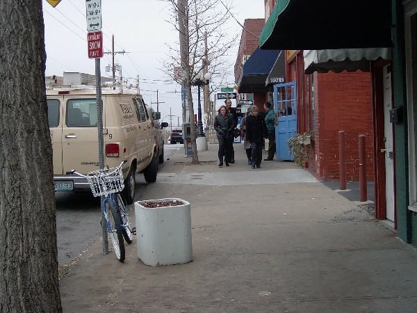
Continuing on a stroll down 39th Street towards the Plaza . . .

Crosswalks with different color paving stone give the intersection of Broadway and 39th Street an attractive look and help raise drivers' awareness of the crosswalks.
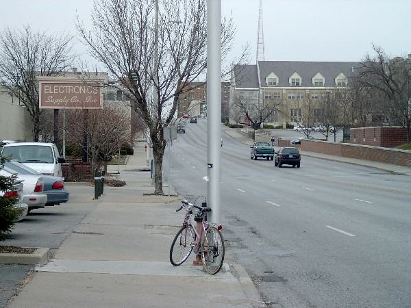
This sidewalk on Main is rather narrow and butts right up against a 6-lane road with rather heavy, fast-moving traffic. But trees and light poles help give a sense of separation. The right-most lane doubles as a parking lane for all but two hours of the day, which helps separate pedestrians from the fastest-moving traffic.
As usual, there is no bicycle parking facility where it is needed.
This pedestrian is crossing mid-block to a section with no sidewalks.
As usual, planners have underestimated the need to pedestrians to travel everywhere, on both sides of the road. This is 47th Street and Main, KCMO.

The gentle curve of this right-turn lane encourages vehicles to make the turn, through the crosswalk, at high speed.
Note the indirect path of the sidewalk. Most pedestrians will cut straight across--as I did.

Sidewalk ends unexpectedly, with no advance warning or indication of alternate routes.
Would the city allow construction workers to treat vehicle routes this same way, simply closing them with no signage and no provision for detour?
|
According to surveys and census data, typically 25%-35% of residents in the Midwest do not have a drivers license. For instance, in Denver, 26% of the population has no drivers license. A further percentage of the population has a valid license but no reliable vehicle, or share a vehicle with another driver. Why? Children, of course, do not have driving privileges, but many adults cannot or do not to drive because of visual disability, revocation of license for legal reasons, motor or mental disability ranging from relatively minor to major, economic reasons, or simple lifestyle choice. |
The bad--and what it can become, for better or worse . . .
This is 59th Street in Raytown. The section between Blue Ridge Cutoff and Raytown Road used to look just like this. Notice:
- Narrow road with crumbling edges.
- Moderate amount of moderately high-speed traffic.
- No sidewalks or shoulders.
- Ditches and brambles on either side of the road--essentially impassible for pedestrians.
My wife and I used to walk 59th Street when it looked like this. There was only one other regular pedestrian we met on the street. She walked along the edge of the road, stepping into the ditch every time an auto passed her--typically several times a minute. She was an elderly woman who enjoyed walking and lived on 59th Street. So she walked for hours daily on 59th Street, following this procedure every step of the way.
You can call her behavior crazy--or you can call lack of sidewalks on a busy, narrow collector street in the middle of a decades-old urban area crazy.
AT any rate, the street was an obvious problem area. Here is what transportation planners wanted to turn it into:
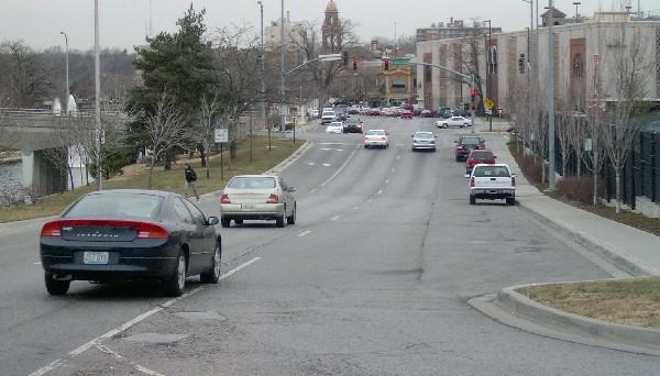
This four-lane "freeway to nowhere" is the tail end of Gregory Boulevard in Raytown. This photo shows Gregory at the height of rush hour on one of the busiest shopping days of the year. Does this road really need to be four lanes?
At the traffic light (past the autos in the photo) this street comes to a T intersection and ends. Why did planners ever imagine it was going to carry a huge volume of traffic?
But the four-lane "freeway" encourages fast driving and discourages pedestrians and cyclists from enjoying what should be a pleasant residential/commercial area.
By the way, the anchor store in the brand-new strip mall, in the right middle-distance of this photo, has been empty for at least five years.
Why is this area dying? It is well-served by heavy, high-speed, four-lane traffic on Gregory and, more particularly 350 Hwy. One couldn't imagine a place with a higher amount of traffic passing by every day. So why is this area dying and a place like 39th and State Line thriving?
Getting back to our story: A four-lane "freeway to nowhere" is exactly what transportation planners envisioned for 59th Street.
Neighbors and city aldermen put up a fuss. They had seen what that sort of road does to neighborhoods. After much discussion, a much better approach was adopted:

These changes have made a tremendous positive improvement in our neighborhood. It is no exaggeration to say that it has transformed it entirely.
Any time I walk or bike on 59th Street I see children and adults walking or biking. People walk to the park (.25 miles distant) rather than driving. Neighbors meet each other on the street.
I didn't dare take my bike on the old, narrow 59th Street. On the new 59th Street I ride most every day.
What does this street have going for it now?
- Sidewalks. Obviously.
- Shoulder/bike lane not only gives more space for cyclists, but also gives more separation between traffic and pedestrians.
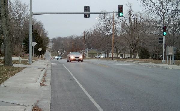
- Mid-block signalized crosswalk to help pedestrians cross to the city park.
- Indy-500-style racing behavior is minimized. Reasonable drivers set the pace. On a four-lane road, you can well bet that the white car (tailgating here) would have roared past both the blue car and the brown car, pegging out at somewhere above 50 MPH before screeching to a halt to enjoy the wait at the next stoplight.
On 59th Street, such behavior is discouraged--not by enforcement nor by signage, but by the design of the road.
Such beneficial compromises could be found for most area roads, if we had the will to find them.
|
The call for more walkable, liveable, and accessible communities, has seen bicycling and walking emerge as an 'indicator species' for the health and well-being of a community. People want to live and work in places where they can safely and conveniently walk and/or bicycle. --US Department of Transportation Policy Statement |
This is where pedestrians typically walk on Missouri's many sidewalk-less streets.
|
Some Missouri-specific statistics: According to the 2000 Census, Kansas City, Missouri, 13% of households (involving about 57,000 individuals) do not own an automobile; for the entire KC metro area the figure is 6% households (involving about 106,000 individuals). St. Louis, MO, has 22% of households are carfree (about 73,000 individuals); the figure for the entire St. Louis metro area is 8% of households (about 210,000 individuals). |
The Ugly
I took a nice walk on Blue Ridge Cutoff and Raytown Road. The section of Raytown Road is in Kansas City, Missouri, and the section of Blue Ridge Cutoff forms the border between Raytown and Kansas City, MO.In between honks and curses from my pleasant neighbors, I managed to squeeze off a few shots showing the state of pedestrian facilities on these roads.
As you can see, these busy, main roads pass numerous residential, retail, and commercial areas in a heavily populated area. Out of approximately 3 miles of road, approximately 300 feet has sidewalk.
Does it need it? Does anyone need to walk here?
You be the judge . . .

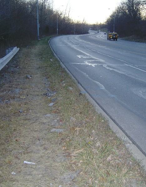
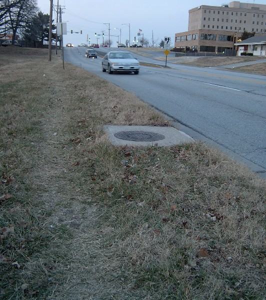
Sidewalk ends at the boundary between Raytown and Kansas City. Where the sidewalk ends is where my walk began . . .
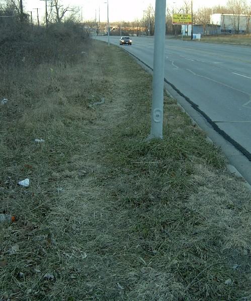
All the spots where the grass have been worn down are due to pedestrian traffic.
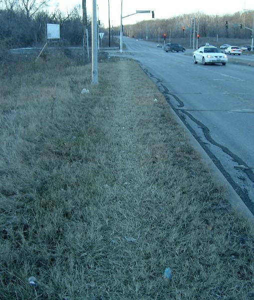
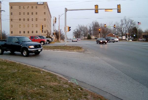
This is the sort of spot that just baffles transportation planners of the old school. This is the intersection of two high-speed expressways. It is a bit of a rural area--there are no houses or businesses in sight. Everything possible has been done to make the area as uncomfortable as possible for pedestrians (must I point out the 50MPH vehicle speeds, rounded corners encouraging high-speed turns without lookout, six lanes of traffic to cross, lack of pedestrian signals at the light, the too-short cycle, and lack of pedestrian trigger on the light--which means that often, in an entire cycle there is no moment when the pedestrian has clear right-of-way across the entire intersection)
Yet still they come . . .
(Looking away from the same intersection towards the south.)
This is so hard to understand until you realize that
- 5000 or more people live within a mile of this point
- There are several bus stops near this intersection
- A nearby very large trailer park has no other exit than on Raytown Road about 1/4 mile from this point.
- Tens of thousands of fans descend on this area many times every year (it is less than 1/2 mile from the sports complex). Often sports fans park wherever they can and make their way to the stadiums however they can . . .
- Pedestrians need to go everywhere motor vehicles go, and for all the same reasons.


Is this getting boring yet?
Intersection of Blue Ridge Cutoff and 63rd Street. Rounded corner encourages drivers to make the turn at high speed.
When and how is the pedestrian supposed to cross?
Note that the sidewalk on the far side of the street (63rd Street in Raytown) disappears on the near side.
Note that the sidewalk disappears both as you turn left (onto Blue Ridge Cutoff) and continue straight ahead (on 63rd Street).
A few pedestrians might have passed by here . . .

and here . . .
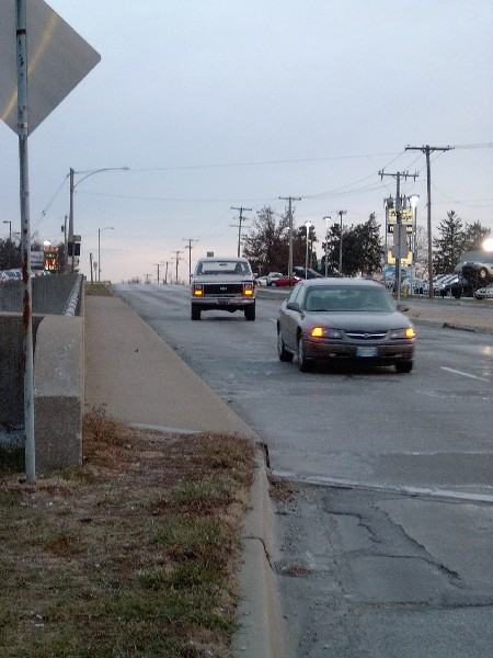
Just a few steps later, the pedestrian shown here was nearly hit by one of the cars shown here making a right turn.
Note absence of sidewalks, crosswalks, or any other pedestrian accommodation. Rounded corner encourages high-speed vehicle turns.
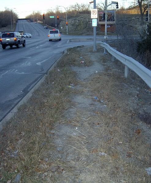
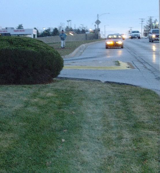
This is the entrance to a shopping complex at Blue Ridge and 350 Hwy. Why would anyone ever want to walk here?
Well, there are easily over 5,000 people living within a one-mile walk of this point. And there are two pedestrians at the intersection just at the moment the photo was taken. And this is a well-marked trail in the grass. And this despite the best effort of planners to discourage pedestrian activity.
Perhaps this is all just a coincidence.
But still, one must ask: What might happen if pedestrian activity were encouraged?
| Pedestrian and bicycle accommodations cost, but the lack of them costs far more. |
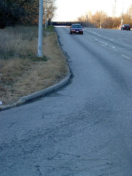
Bridge over 350 Hwy. Traffic often hits 50MPH+ here. A little more separation between pedestrian and vehicles would be pleasant. But at least there are sidewalks here!
Reverse view of the same bridge. Do you think this sub-standard sidewalk gets any actual use?
(Hint: Note ruts in grass leading up to it . . . )
|
Transportation planners and engineers . . . have the same level of responsibility to provide for the safety of bicyclists and pedestrians as they do for motorists. --Transportation Planning Handbook |
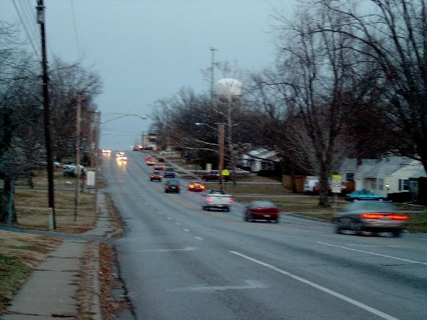
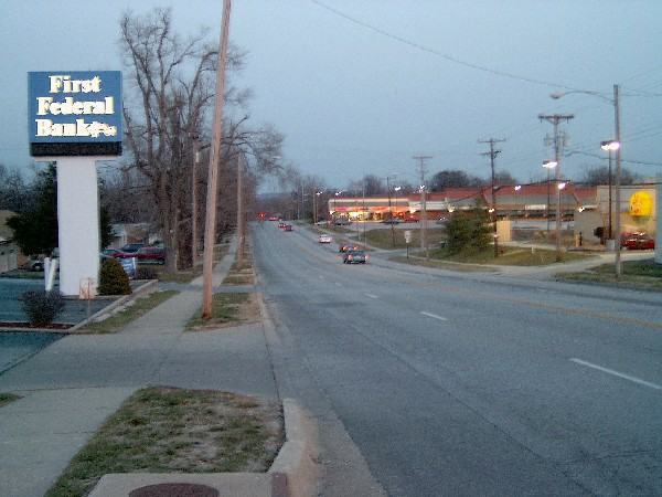
Now we turn east onto Gregory. This is at the very peak of rush-hour traffic. Does this really need to be a four-lane road?
It might appear so at this moment. But this is a platoon of traffic created by a nearby traffic light, at the very peak of rush hour on one of the busiest shopping days of the year. So this is a very peak moment of a peak time of day on a peak day of the year.
And still all this traffic would fit comfortably on a 3-lane road (two travel lanes plus center turn lane). On a three-lane road, the traffic would travel more smoothly (because left-turners wouldn't impede traffic behind them) and there would be room for nice 6-foot shoulders/bike lines on each side of the road.

Here is the same street just 30 seconds later.
Does this street really need to be a four-lane "freeway to nowhere"?
|
Four lane road-
ways often generate excessive speeds. These road-
ways also erode the ability for transit, walking and
bicycling to succeed. How does this happen? Motorists using four-lane roadways, note that there are
always spare lanes in their direction. They tend to
drive faster than they should. . . . During peak
volumes, right or left-turning movements occur. . . . Motorists move from lanes of
slowing vehicles directly into the backs of other motorists who
have already slowed for their turns. --Dan Burden, Road Diets: Losing width and gaining respect |
Ugly Squared
This is positively worst-designed intersection for pedestrians I have ever seen anywhere.It is at the corner of 350 Hwy and Gregory Blvd.
In the recent past it has been the policy of MoDOT to design their highways in complete disregard of the needs of pedestrians--and it shows.
MoDOT has been changing and updating their policies recently, and we will expect much better from them in the future.
The corner of 350 Hwy and Gregory is loaded with retail businesses begging for customers. Over 5000 (perhaps as many as 10,000) people live within an easy one mile walk of this point. But why would we need to make the area pleasant for pedestrians? It is much easier to help people on their way to Lee's Summit drive through here at the fastest possible speed . . .
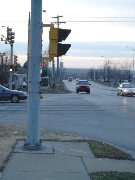
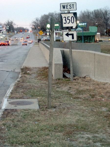
Let's start with the approach to the intersection. Just a few hundred feet back there was a pleasant sidewalk. Now the sidewalk is history and in its place is a pole and a deep pit:
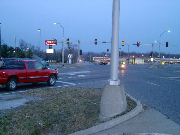
Here is a view of the same intersection from the opposite direction:

What is wrong here?
- 350 Hwy divides Raytown in half. There are pleasant neighborhoods within a few hundred feet of both sides of this intersection. Gregory is the only through street crossing 350 Hwy for approx. one mile in either direction. Neither of those alternative ways of crossing 350 Hwy is especially pedestrian-friendly, either. So if pedestrians want or need to cross 350 Hwy to get from one side of Raytown to another, here is the most likely place they will need to do it.
- 50 MPH traffic on 350 Hwy, 35 MPH on Gregory.
- Wide radius corners encourage high-speed turns.
- Six lanes of traffic to cross when crossing 350 Hwy (four travel lanes plus two left-turn lanes). This doesn't count the right-turn traffic that might cross the pedestrian's path from behind him on Gregory or to his right front on 350 Hwy.
- No marked crosswalks.
- No pedestrian crossing signals.
- Skewed intersection angle makes pedestrian distance to be traversed even longer yet.
- The signal's cycle is far too short to cross all these lanes of traffic, even for a highly motivated healthy young man moving at high speed. (This is the voice of experience speaking.)
- Because of the complex cycle of the light, with complicated non-standard left-turn signals and lanes, it is very difficult for the pedestrian to determine when he has a clear right-of-way.
- In fact, there is no time when the pedestrian has clear right-of-way to cross without any traffic conflicts. In the best possible situation (which lasts only a few short seconds) the pedestrian has traffic legally and lawfully crossing his path from three different directions--two of which he cannot see clearly.
A pedestrian crossing at the intersection, by contrast, must be aware of fast-moving traffic crossing his path coming from seven different directions, including some from both sides and from the rear, some going straight and some turning in various complicated ways.
Jaywalking a few hundred feet from the intersection is much simpler and, because of that, much safer.
Here is the same intersection from a bit further back:
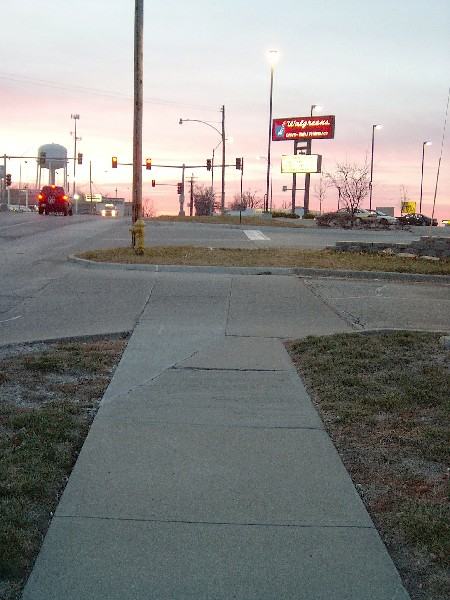
Note the commercial driveways that further complicate this intersection.
But above all, note the "sidewalk to nowhere".
We certainly don't want pedestrians to approach the intersection, so it is for a wise reason that the sidewalk stops here, a few feet short of it. Perhaps the pedestrians will become confused, mill about at random, and most of them will never even find the mortally dangerous intersection.
Or something . . .
|
Even where bicyclists and pedestrians may not commonly use a particular travel corridor that is being improved or constructed, they will likely need to be able to cross that corridor safely and conveniently. Therefore, the design of intersections and interchanges shall accommodate bicyclists and pedestrians in a manner that is safe, accessible and convenient.
--Federal Highway Administration, U.S. Department of Transportation |
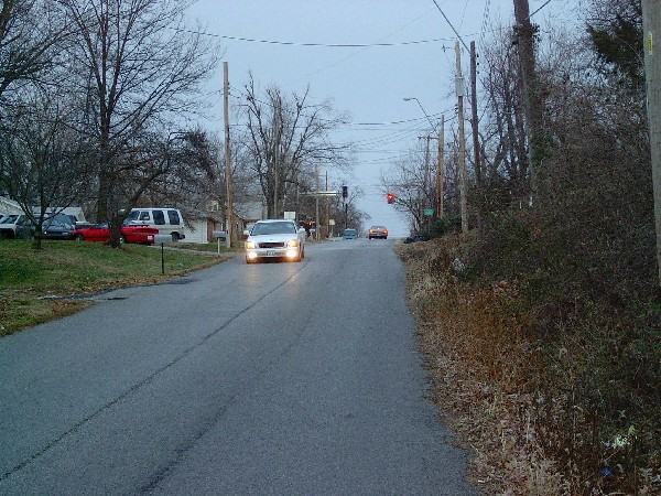
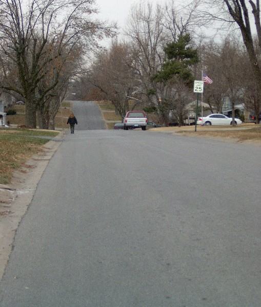
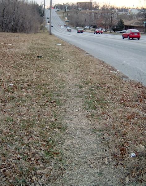
These are typical residential streets in eastern Jackson County, Missouri:
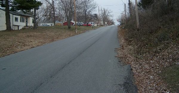

One problem with such long, straight streets with little traffic, is that motorists can see no reason to restrain their speed below 40 MPH.
Combine this with a few blind hills, and most pedestrians find a reason to stay indoors.
|
There is no question that conditions for bicycling and walking need to be improved in every community in the United States; it is no longer acceptable that 6,000 bicyclists and pedestrians are killed in traffic every year, that people with disabilities cannot travel without encountering barriers, and that two desirable and efficient modes of travel have been made difficult and uncomfortable. --Federal Highway Administration, U.S. Department of Transportation |
--Brent Hugh
bhugh@mwsc.edu
Raytown, Missouri
26 December 2002
The above text and photos are hereby placed in the public domain. Anyone may use them for any purpose whatsoever without seeking my permission.
Sidewalks to Nowhere
Kansas City Streets as seen from the seat of a bicycle
Brent Hugh's Bicycle Advocacy page